The Viaduct, Botchergate & Caldewgate (aerial)
Four more cards from Ian's collection.
 This is a nice card from around 1905-10. Several modes of transport here, the early tram, the very early motor car and a pony and trap.
On the left is the northern end of the Gaol Tap block and the gaol wall beyond with Bush Brow heading down towards the station.
Most of the buildings on the right survive with the exception of the one just past the awnings which was demolished to make way for Tesco's.
 Botchergate looking north C.1920s-early 30s. The Ironmongery shop of John Gaddes Parker certainly has an impressive display of goods.
 Next door is the Carlisle Picture House.
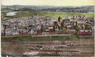
 The first of two interesting cards of the views of Caldewgate area from Dixon's Chimney.
Most of the railway yard at the bottom of the card is now the Town Dyke Orchard car park, originally a public recreation ground.
Right centre of the picture on West Walls can be seen the Fawcett School (National) and just a glimpse of the old police station.
At the top of the card just left of centre is the Turf Inn.
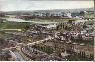
 Again from Dixon's Chimney this shot takes in the top of Caldewgate.
BEARINGS .. On the extreme left of the card on the far side of the road is the Globe Inn, a little further up the road the white building still stands and opposite this is the entrance to Milbourne Street. The block of houses opposite the white building ( Brewery Row, Richard St. & part of Milbourne St) have all been demolished , some as late as the early 1960s.
The 'river' in the botton left of the picture is the Little Caldew, part of the mill race that ran from Holme Head to the Eden at Willowholme, to the left of this are some of the buildings that used to occupy the site of what is now Paddy's Market car park today.
Devonshire Walk car park was then a hive of industry with Dye Works, the Corporation Slaughter House and various other industries.
KEEP SCROLLING DOWN.
 Here are the two cards joined together.
0 Comments:
Post a Comment
<< Home