Carlisle Postcards

Wednesday, April 19, 2006

Rickergate, Carlisle Fair & The Volunteer Fire Brigade


Click on image to enlarge.

Rickergate probably obtained its name from Richard (personal name) and gata (street), access to Rickerby (Richard's land) would be from The Scotch Gate and this street.

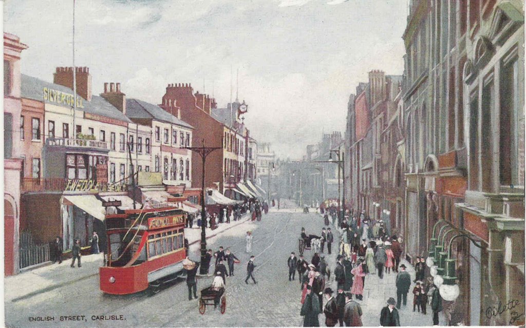
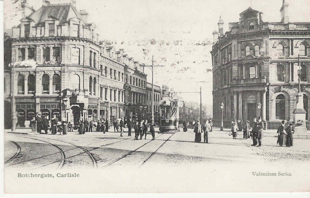
In this view of about 1903 imagine yourself standing outside Debenhams entrance at the bottom of Scotch St and looking down towards the Civic Centre which stands just about where the end buildings are on the right.

None of these buildings remain today although parts of Rickergate were only demolished in the 1960s to make way for the Civic Centre.

Rickergate itself only began where Warwick Street is today and on the other side where Drovers Lane used to be. Jardine Carruthers the Ironmongers address is 10 Scotch Street. Next to him (the shop with the clock) is Frederick Goodger (Watchmaker).

In the short distance from the Civic Centre to Drovers Lane Rickergate in 1906 had no less than SIX public houses being .. The Drove Inn .. The Ship Inn .. The Fox & Hounds .. The Durham Ox .. The Bay Horse and The Three Crowns. The opposite side had only four .. The Malt Shovel .. The Blue Bell .. The Scotch Arms and The Wheatsheaf Inn. Not bad for street only about 200 metres long either side.

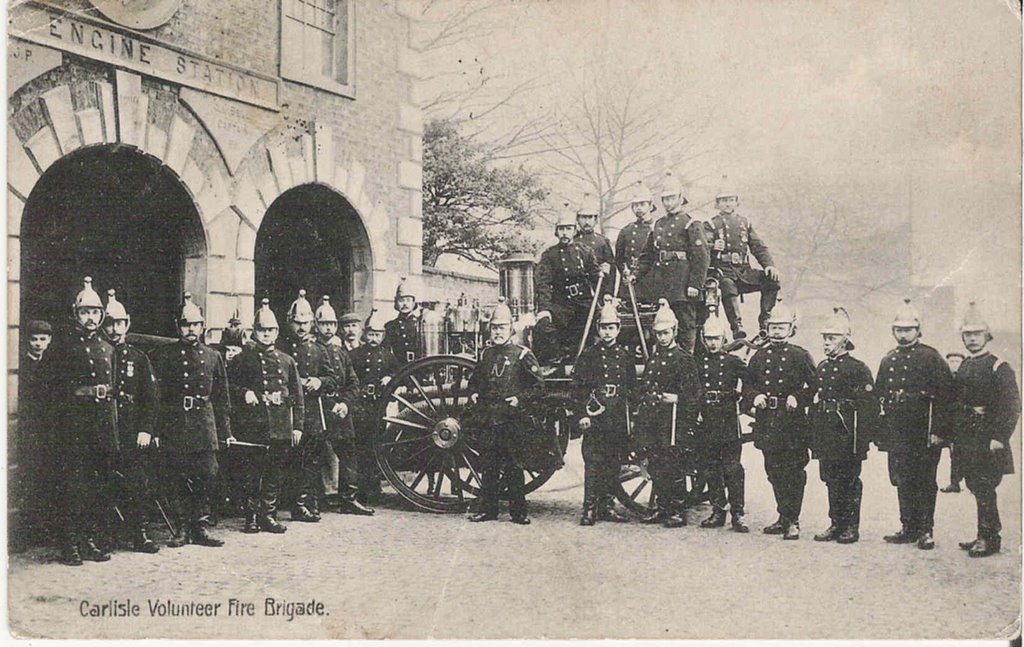
Carlisle Volunteer Fire Brigade in their new station in Spring Gardens Lane (the little street that runs along where the Bowling Green Hostel is today).

The picture must be from between 1896 (when the station was opened) and 1904 (when the Volunteers were disbanded).

I wonder how much those helmets would make on Ebay today?


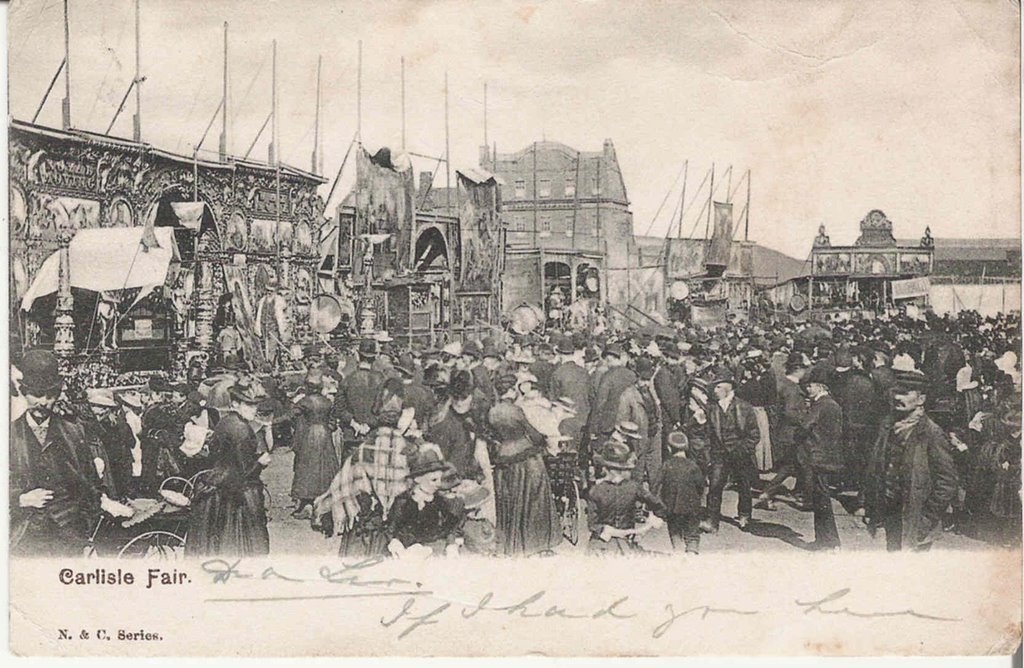
Last of all is this card of Carlisle Fair which was held on the Sands, The Turf Inn can be seen in the background.

The fun of the fair would have included boxing booths, freak shows, some wild animals as well as rides.

No doubt they proved profitable for some of Carlisle's dodgier characters.


This is the last of the cards for now, new cards will be posted as and when obtained. hope you've enjoyed them. David alias Paddock.

Don't forget you can always leave a comment if you have any info. on any of the cards or if you have any cards you want to sell, remember I'm only a poor old pensioner though. :-)


Monday, April 17, 2006

Castle St, Caldewgate and Proclaiming the Great Fair

Click on images to enlarge.

This card of Castle St. is from the early 1900s. The large building on the right is Poundstretchers today, then partly occupied by Mary Blaylock, Toy Dealer.

The small shabby looking shop next to it is Robert Strong's fishing tackle shop, run at this time by John Strong.

Thanks to Jim for this card.


Caldewgate, probably in the 1920s as the trams are still running.

The little row of cottages in front of Carrs stood until fairly recently. The building lower right is the Regal Cinema now The Bike Shop and the next one is where Gordon Box's car saleroom is today (the building looks to be in the process of being demolished).

At the top of the road in the centre can be seen the block that housed Tiffens the motorcycle dealers and the Irishgate Tavern (closed April 1971).


Proclaiming Carlisle Fair August 26th 1910. The Mayor I believe is Sir Benjamin Scott.

Looks like a nice summers day.

The right to hold a fair was granted by Edward III in 1352 'and a fair on the feast of the assumption of the blessed Mary in each year for fifteen days next following the said feast'.

Saturday, April 15, 2006

Morton Manor, The County Hotel and the Gaol Tap block

Click on images to enlarge.

Morton Manor, built just after 1807 for the Forsters who had banking interests in the city. In 1853 it was bought by Joseph Ferguson (textile manufacturer), when he died in the late 1890s he left it to the Chances (nephews). Frederick Chance lived here and left it to Robert Chance who offered it to the city for community use in 1944. The Chances lived here until 1960 when Sir Robert died.


The Deanery at the Cathedral looking much the same as it does today. Within it is the Priors Tower with its painted ceiling.


Photo card of the area around the cathedral in the early 1950s.

St. Marys church to the right of the cathedral was demolished in 1954.

Top right can be seen one of the buildings of West Tower St and along the top houses on and behind Corporation Road many of which have been demolished. Top left is a section of the Salvation Army Citadel.


The County Hotel sometime before 1905, the lane in the centre leads to Collier Lane.

The original hotel was built in 1852 and extended 1866-68.


The building on the right is the rear end of the Gaol Tap block, Dands is where the Cumberland Building Society is now. At the bottom on Lowther St is the General Post Office now Lloyds TSB.

Foster and Downey were Grocers and Italian warehousemen, a refreshment room was also in the building.

Dands were Saddlers and Trunk Makers .

The shop with the ornate glass window is J.W. Johnston & Son, Watchmakers, Jewellers and Silversmiths.


The end of the Gaol Tap block is on the left and it can be imagined how much this block narrowed English St. Dands is on the right and on the left is J. Hepworth (Manufacturing Clothier).

Both this card and the one above are earlier than 1906, the date of posting.

Thursday, April 13, 2006

English St, The Viaduct, St Albans Row and a Royal Visit.

Click on images to enlarge.

No date on this card but both Liptons and Maypole shops are in the 1914 Carlisle Directory, although I think this is slightly earlier.

On the left is the Maypole Dairy Co. Ltd and opposite it is Liptons Limited (Grocers). Older people may remember their mothers saying something along the lines of 'That womans got more faces than Tommy Lipton has sugarbags'.

A nice bright day on English St, George Tweddle the Hatter is on the left and next to it I think is Boots Drug Store.


Similar view to the previous card but with a nice close-up of a tram. Look at the great lighting on the shop on the right.


A nice card of St. Albans Row in the very early 20th C., the card was posted in 1905.

On the left is Ormans (Fish and game Merchants) then James Lomas's Oyster Bar. Just past this is The Old Queens Head Hotel run by Sanderson Carey.

The Viaduct in the early 1920s. The Gaol wall is on the left with Bush Brow running down from it. The sign on the tram powerline post reads 'ALL CARS STOP HERE', an early bus stop.

On the right we have the National Union and Provincial Bank Ltd, the Home & Colonial Stores and the Viaduct Hotel.


This will be the visit Princess Louise made in 1908 to lay the foundation stone for the Infirmary extensions, people are crowded onto every vantage point, all in their best clothes.

Glaister the Confectioners is on the left as is Nicholson & Cartner (Glass, China and Postcard seller)

Tuesday, April 11, 2006

English Street

Click on images to enlarge.

A quiet day in the city in this scene of about 1910. A tram trundles towards Botchergate heading for either London Road or St. Nicholas Bridges.

The Gaol Tap block is in the centre rear.


A scene in the late 1940s is my best guess.

Leo Scott the Opticians is on the right.


Although this card was posted in 1927 I think the scene is a good bit earlier.

I think the horsedrawn wagon is delivering to the Victoria Hotel.

Lord Lonsdale looks down on a group of men who have stopped for a natter, are they discussing how well Carlisle United are doing?


This is about 1933-34, the tram lines have not yet been removed.

Although most vehicles are now engine-powered a hand cart is still being pushed along.

The pavements are jam-packed in this card posted in 1925, but very little vehicular traffic.

I wonder if they are coming or going to a special event or is it just a busy shopping day?


Whoooo-oooo, it's a tram, but most of the traffic is horse-drawn. The card was posted in 1908.

The rear end of the Gaol Tap block can be seen in the distance on the right (more of this later)

Sunday, April 09, 2006

In the Olden Time, by the Park and the Circus

Click on images to enlarge

This card is an image take from 'Carlisle In The Olden Time' by M.E. Nutter printed in the early 19th C.

There was at this time buildings attached to the Cathedral, which when added to the wall in the picture prevented a good view of the outside of the East Window.


This is a view of the Town Hall in 1780, the most obvious difference from todays view is that the fan steps have been replaced.

Whilst the Town Hall belonged to the city, the shops below were private property, which, the author says prevented the demolition of this building and its being replaced by a more fitting building.


The English Gate was not between the two Citadels but on the West Walls about 100-150 yards further on. It was demolished in 1811 and its foundations removed in 1817.

The Gaol is probably the one built in 1688.


The Carel Cross of 1682, meeting place, symbol of authority and a place to rest weary legs. It was here the Rudd women used to sell their pieces of sandstones use for colouring steps an window sills. Around its steps the market used to be held and the farm hirings took place.

If you look on the steps you will find an arrow, this signifies it is government property just as the arrows on prison clothing denoted they too were government property.


A View of the bandstand in Victoria Park in the 1900s. the first concert was in 1894 and it was demolished in 1957.


The circus comes to town. Sangers visited Carlisle in 1865, but I think this is a later image of a circus around 1890, perhaps they revisited the city.


Posted in 1905 this card shows a winter scene on The Avenue. All are well wrapped up against the cold.

Friday, April 07, 2006

Old cars & buses by the Courts and Newtown.

Click on images to enlarge.

A nice card of The Crescent in the 1930s or 40s. Park anywhere seems to be the order of the day. I think the cars on the left are taxis.


A very clean looking Carlisle in this card of the 1930s. Taxis are parked in front of the taxi-drivers restroom with the underground toilets just behind. Two proud parents are pushing their sprog towards the station.


A scene in the late 1920s, there appears to be quite a crowd of people gathering at the Crescent. A nice sunny day, all seats are taken in the gardens.


A view of the Courts with the Tollbooth outside


A little later this one, we're into the 1950s. Again the taxis are parked in front of the drivers rest hut and the shops on The Crescent are open for business.


Newtown Road from about The Pedestrian Arms. Date unknown but about 1910.

The little girl outside the 4th opening up is Nancy, the message on the card reads 'Dear Edie, have sent you photo of our house, the fourth door with Nancy standing at the bottom of the steps'. This block was originally named Clift Terrace, the sign is still above the nursery at the Infirmary end of the block.

Bower street is on the left, the shop is Henry Wood, Baker and Post Office. Again, the road is looking very clean.

Wednesday, April 05, 2006

Botchergate, The Castle and down by the river

Click on images to enlarge

A scene probably in the 1920s or early 30s, kids playing in the river just down from Eden Bridges. Eden Terrace can be seen to the left of the bridge, this stood where the Chinese Gardens are now.


An early card of a tram in Carlisle, the card was posted in 1904 and the trams only started running in 1900. What is now the Griffin would then have been The Cumberland Union Banking Co. Ltd.


Another busy scene at the top of Botchergate. Looks to be a pleasant day, the boaters are out in force. As can be seen the pavement then ran round the outside of the 'arches' which were surrounded by railings, this made for a much narrower street than now.

Botchergate (Botchardus's street) was one way of reaching Botcherby before Warwick Road was built. Botcherby was known as Bocherby in 1170, a 'by' was a parcel of land, Botchardus was probably of Norman origin. It became part of the city in 1912.


3 cards of the castle to finish the castle cards off. Possibly the 1920s, it shows the WWI tank that was given to the city by the National Savings Committee.


The posters either side of the gate are probably recruitment posters. The image is from the 1930s.

The negative No. for this card dates it between 1900-10. The Salvation Army Citadel is on the left of the picture.