Carlisle Postcards

Friday, May 26, 2006

The Old Guild Hall, Carlisle HUTHARTS SHOP

CLICK IMAGE TO ENLARGE.

Date around 1910-20.

Hutharts was an old established firm, the legend on the back of the card says it had been in existence for almost 100 years at the time of this card.

As can be seen it also occupied a site on Fisher St.

The writing under the Guildhall window reads 'REPAIRED 1844' .

Have a look next time you're passing and see how the doors and windows have changed.

On the right hand building between the windows there is a 'fire plaque' denoting which insurance company insured the building. If the fire service arrived at a fire and you had no plaque or the wrong plaque the building was allowed to burn. There is also one on a farmhouse at Tarraby (this is NOT Yorkshire speak for Harraby :-) ).

Friday, May 12, 2006

The Viaduct, Botchergate & Caldewgate (aerial)

CLICK ON IMAGES TO ENLARGE.

Four more cards from Ian's collection.

This is a nice card from around 1905-10. Several modes of transport here, the early tram, the very early motor car and a pony and trap.

On the left is the northern end of the Gaol Tap block and the gaol wall beyond with Bush Brow heading down towards the station.

Most of the buildings on the right survive with the exception of the one just past the awnings which was demolished to make way for Tesco's.


Botchergate looking north C.1920s-early 30s. The Ironmongery shop of John Gaddes Parker certainly has an impressive display of goods.

Next door is the Carlisle Picture House.


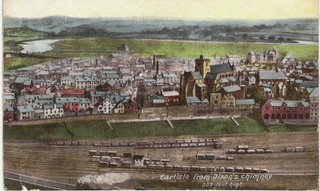
The first of two interesting cards of the views of Caldewgate area from Dixon's Chimney.

Most of the railway yard at the bottom of the card is now the Town Dyke Orchard car park, originally a public recreation ground.

Right centre of the picture on West Walls can be seen the Fawcett School (National) and just a glimpse of the old police station.

At the top of the card just left of centre is the Turf Inn.


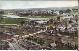
Again from Dixon's Chimney this shot takes in the top of Caldewgate.

BEARINGS .. On the extreme left of the card on the far side of the road is the Globe Inn, a little further up the road the white building still stands and opposite this is the entrance to Milbourne Street. The block of houses opposite the white building ( Brewery Row, Richard St. & part of Milbourne St) have all been demolished , some as late as the early 1960s.

The 'river' in the botton left of the picture is the Little Caldew, part of the mill race that ran from Holme Head to the Eden at Willowholme, to the left of this are some of the buildings that used to occupy the site of what is now Paddy's Market car park today.

Devonshire Walk car park was then a hive of industry with Dye Works, the Corporation Slaughter House and various other industries.

KEEP SCROLLING DOWN.


Here are the two cards joined together.

Wednesday, May 10, 2006

Scotland Road, Gretna Tavern & Aerial Shot.

CLICK ON IMAGES TO ENLARGE.

Four more cards from Ian Yate's collection.

The Gretna Tavern, now Lloyds TSB, opened July 12th 1916, probably as part of the initiative to encourage eating as well as drinking in Carlisle's pubs. The State Management Scheme was to be inaugurated just three days later.

The scheme was in answer to the rampant drunkenness rife in Carlisle by workers employed on the building of the Gretna Munitions Factory (this may explain the name of the tavern).


Card showing the then 'luxurious' interior of the Tavern.

Many of Carlisle's 'new' State Control pubs were being encouraged to sell food as the 'demon drink' didn't have as much effect when taken with food.


An aerial shot of Carlisle 1930s or 1940s.

The large grassed area at the bottom of the screen is where the new Technical College is taking shape. The path behind it (Zero Path) is the one that leads from the Turf Inn to Strand Road.

Top left is the market, you can follow West & East Tower St. from here until it reaches Lowther St (with Lowther St. School and H.M.Theatre opposite).

Top right is the Turf Inn and the cattle pens on the Sands. Coming over Eden Bridges in a straight line you can make out George St (Maternity Hospital used to be here) and continuing the line to Spencer St. you can see what was demolished to make way for Georgian Way.

A very interesting card.

This card shows Etterby St. on the left, with the old Crown Inn just beyond (new one completed Dec. 1937).

Most of the buildings on the right are now part of the Cumbria Park Hotel, beyond these houses there would have been little until Moorville and then Kingstown.

Probably about 1920 going by the car.

Notice the tram stop on the left.

Sunday, May 07, 2006

H.M Theatre, Proclamations and Stanwix Bank.

CLICK ON IMAGES TO ENLARGE.

These four cards have been loaned to me by Ian Yates, another collector. Thanks Ian.

November 11th 1918, Mayor announcing the Armistice.

No empty spaces as the Mayor announces the end of four years of war. As can be seen most people wore hats then and many would have been made at Carrick's Hattery Works in Dentonholme.

Plunketts the Drapers is to the right of the steps, Fairbairns was a Seed Merchants.


These are the cottages that used to stand at the junction of Stanwix Bank and Brampton Road.

The board on the end of the house gives mileages to various places Longtown, Brampton etc.

Their water came from a pump situated in front of the house.

Demolished around 1903 when the present large house was built.


Packed house at Her Majesty's Theatre on Feb. 24rd 1907 for a performance of the opera 'Maritana'.

Erected in 1874 as The Victoria Hall, renamed H.M. Theatre in 1879, badly damaged by fire in Sept 1904 it reopened a year later. It closed as a theatre in Jan. 1963. Continued in use as a Bingo Hall from late 63 onwards, finally demolished in 1979.


The Proclamation of King George V. at the Carel Cross May 10th, 1910.

As is evident, huge crowds turned out for these events, no tellies in those days, if you wanted to see the event, you had to be there.

The Mayor is on the steps with the two heralds in front and it is probably the Border Regiment behind them (the band?).

Hats are much in evidence as usual in all shapes and forms.

Thanks again to Ian for the loan of the cards.